

Main Facts: Bringing Global Heritage into Focus
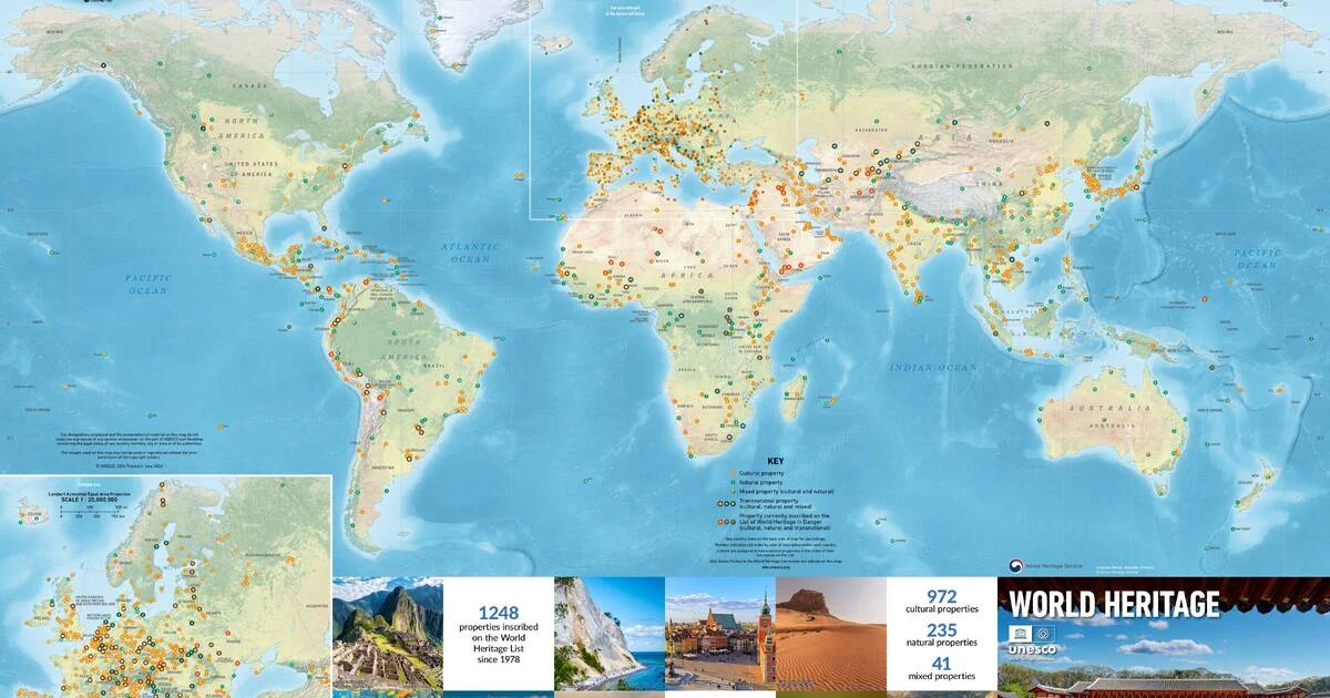
The United Nations Educational, Scientific and Cultural Organization (UNESCO), in collaboration with the cartographic experts at Geo4Map and with the strategic support of the Republic of Korea, has officially launched the latest edition of the World Heritage Wall Map. This meticulously curated document is more than a mere geographical reference; it serves as a visual manifesto of humanity’s shared cultural and natural legacy.
Spanning the globe, the new poster-sized map provides a comprehensive catalog of the 1,248 sites currently inscribed on the World Heritage List. Each location—from the towering peaks of the Himalayas to the intricate urban centers of Europe and the pristine archipelagos of the Pacific—is represented through a blend of high-definition cartography and evocative photography. The map is designed to be an educational tool, offering viewers a panoramic perspective of the world’s most significant landmarks, their geographical distribution, and the essential data required to understand their protected status.
At the heart of this year’s visual narrative is the Jongmyo Shrine in the Republic of Korea. Chosen for its historical gravitas and architectural integrity, the site serves as the map’s centerpiece. As the oldest and most authentic Confucian royal shrine, the Jongmyo Shrine represents a pinnacle of cultural continuity, where architectural layout and ritualistic practice have remained largely unchanged for centuries.
Chronology: The Evolution of World Heritage Documentation
To understand the significance of this latest map, one must examine the evolution of UNESCO’s commitment to geographical documentation since the adoption of the Convention Concerning the Protection of the World Cultural and Natural Heritage in 1972.
- 1972: The World Heritage Convention is adopted, establishing the framework for identifying sites of "Outstanding Universal Value."
- 1978: The first twelve sites are inscribed, marking the beginning of a long-term documentation process.
- 1990s: As the list grew rapidly, the need for a consolidated visual reference became apparent. UNESCO began producing physical wall maps to facilitate public education and diplomatic awareness.
- 2010s: The transition toward digital mapping and high-resolution printing technologies allowed for the inclusion of thousands of sites on a single poster without compromising legibility.
- 2024: The latest edition is released, incorporating the most recent inscriptions and reflecting a sophisticated collaboration between the World Heritage Centre and Geo4Map.
The history of the World Heritage Map is, in many ways, a history of the expansion of human consciousness regarding environmental and cultural preservation. Each iteration of the map has acted as a snapshot of a growing global consensus on what is worth saving for future generations.
Supporting Data: The Anatomy of the 1,248 Sites
The sheer scale of the 1,248 World Heritage properties can be overwhelming, yet the new map distills this complexity into digestible data sets. The sites are categorized into three primary types: Cultural, Natural, and Mixed.
The Distribution Matrix
While the map is a physical artifact, the data behind it reveals profound patterns of human settlement and geological significance.
- Cultural Sites: The vast majority of inscriptions fall under this category. These sites include monuments, groups of buildings, and sites of historical, aesthetic, or archaeological importance.
- Natural Sites: These include geological formations, physiographical regions, and natural habitats of threatened species of animals and plants.
- Mixed Sites: These rare locations possess both outstanding cultural and natural significance, representing a convergence of human intervention and environmental majesty.
The Jongmyo Shrine: A Case Study in Preservation
The featured imagery of the Jongmyo Shrine is not merely decorative; it is a pedagogical choice. The site, dedicated to the ancestors of the Joseon dynasty (1392–1910), provides a profound example of "living heritage." Unlike archaeological sites that remain frozen in time, the Jongmyo Shrine maintains the continuity of Jongmyo Jerye—the royal ancestral ritual—which is itself inscribed on the Representative List of the Intangible Cultural Heritage of Humanity. By featuring this site, the map highlights the dual importance of physical preservation and the maintenance of traditional customs.
Official Responses and Diplomatic Context
The partnership between the World Heritage Centre and the Republic of Korea underscores the critical role of international cooperation in cultural preservation. In a joint statement, representatives from the World Heritage Centre noted that the map is designed to foster a sense of "global stewardship."
"This map is a bridge between the local and the global," said a spokesperson for the World Heritage Centre. "By placing the Jongmyo Shrine at the forefront, we are celebrating the dedication of nations that work tirelessly to maintain the authenticity of their heritage despite the pressures of rapid modernization."
The government of the Republic of Korea, which provided the necessary support for the production and distribution of the map, emphasized that the project aligns with their long-standing policy of promoting "Cultural Diplomacy." By subsidizing the map’s production, South Korea has ensured that this valuable educational resource remains accessible to academic institutions, libraries, and heritage enthusiasts worldwide.
Implications: The Role of the Map in Modern Conservation
The release of the 2024 World Heritage Map carries significant implications for the future of heritage advocacy and education.
Enhancing Public Literacy
In an age of digital saturation, the physical wall map offers a unique advantage: it provides a holistic view of the world that a screen often obscures. By displaying all 1,248 sites simultaneously, the map allows researchers and students to draw connections between distant regions. One can observe, for instance, the concentration of sites along the ancient Silk Road or the correlation between biodiversity hotspots and natural World Heritage sites.
Advocacy and Awareness
The map serves as a vital advocacy tool. When a site is depicted on a global document of this stature, it reinforces its international profile. This, in turn, can influence government policy, encourage tourism in neglected regions, and bolster local pride. For sites currently facing threats from climate change or armed conflict, their inclusion on the map is a silent but powerful reminder of their global importance—a nudge to the international community to provide the resources necessary for their survival.
A Tool for Future Generations
The 2024 map is intended to be more than a static image; it is an invitation to engage. The World Heritage Centre encourages institutions to use the map as a foundation for classroom discussions on history, geography, and environmental science. By visualizing the breadth of human achievement and natural beauty, the map helps to cultivate a generation of global citizens who understand that their local heritage is part of a much larger, interconnected tapestry.
How to Acquire the Map
The 2024 World Heritage Wall Map is currently available for order through the official UNESCO World Heritage Centre website. Recognizing the demand from academic institutions and NGOs, the distribution model is designed to facilitate bulk orders for schools and cultural centers.
As the world faces unprecedented challenges—from the degradation of ecosystems to the homogenization of culture—the act of documenting and celebrating our collective heritage is more vital than ever. The new map stands as a testament to this commitment, reminding us that while we are separated by geography, we are united by the stories we tell about our past and the responsibility we hold for our future.
For those interested in the technical specifications or in exploring the digital versions of these sites, the World Heritage Centre also provides an interactive portal that complements the physical map, offering virtual tours and deep-dive data on every one of the 1,248 properties. Whether hung in a university lecture hall or a living room, this map serves as a perpetual reminder of the fragility and the enduring splendor of the human experience on Earth.
 Asep Darmawan
  Evan Lee Salim
  Jia Lissa