

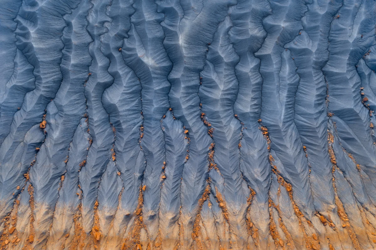
To the casual traveler crossing the American West, the landscape often blurs into a monochromatic monotony—a vast, sun-bleached tapestry of sagebrush and gray-blue ridges. For the uninitiated, it is merely a stretch of road to be endured, a barren expanse of "badlands" that separates the iconic arches of Moab from the soaring peaks of the Rockies. Yet, for those who look closely, there lies an unsung protagonist of the Colorado Plateau: the Mancos Shale.
Ninety million years ago, this rugged terrain did not exist. Instead, the region was submerged beneath the Western Interior Seaway, a massive inland ocean that bisected North America. The sediment that settled on the floor of that Cretaceous sea—fine-grained silt and clay—eventually compressed into the Mancos Shale, a formation that now covers immense swaths of New Mexico, Arizona, Colorado, Wyoming, and Utah. While it lacks the sheer, postcard-ready verticality of the Navajo Sandstone or the vibrant iron-rich hues of the Wingate formation, the Mancos Shale is the skeletal architecture of the West, a geological foundation that dictates the hydrology, ecology, and human history of the region.
The Cretaceous Archive: A Chronological History
The story of the Mancos Shale begins in the Late Cretaceous period, roughly 90 million years ago. During this epoch, tectonic activity and fluctuating sea levels created a vast, shallow corridor of water that stretched from the Gulf of Mexico to the Arctic Ocean.
The Deposition Era
As the seaway deepened and shallowed in cycles, rivers flowing from the nascent Rocky Mountains deposited vast quantities of mud, silt, and clay into the basin. These layers, buried under the weight of subsequent millennia, underwent diagenesis—the process of chemical and physical change that turns sediment into stone. The result was a thick, crumbly, and highly erodible mudstone.
The Uplift and Exposure
Following the retreat of the seaway, the Laramide Orogeny—a period of mountain building—pushed these flat-lying marine sediments upward. As the Colorado Plateau rose, the forces of wind and water began to carve away the softer overburden, exposing the Mancos Shale to the harsh, arid climate of the modern American West. Unlike harder, more resistant rocks, the Mancos is notoriously "friable," meaning it breaks down into fine dust with ease. This characteristic has resulted in the formation of iconic "badland" topographies, where every rainfall sculpts intricate, ephemeral drainage patterns—fractals in the dirt that change with every storm.
Supporting Data: The Science of the Shale
The Mancos Shale is not merely a geological curiosity; it is a critical scientific ledger. Because it was deposited in a marine environment, the formation is a treasure trove for paleontologists.
- Paleontological Significance: The shale contains a wealth of fossils, particularly ammonites—extinct cephalopods that serve as "index fossils" for geologists to date the surrounding strata. Shark teeth, marine reptile remains, and fish scales are also frequently unearthed, providing a detailed snapshot of a vibrant, long-lost marine ecosystem.
- Geochemical Composition: The formation is characterized by its high clay content, specifically illite and smectite. This composition makes the soil highly expansive when wet and prone to rapid erosion. From a hydrological perspective, the Mancos Shale acts as a confining layer, often preventing the downward percolation of groundwater, which leads to the formation of localized, highly saline springs.
- Mineral Resources: Beyond its scientific value, the Mancos is a significant hydrocarbon-bearing formation. It is a primary source rock for oil and natural gas across the Rocky Mountain region, as the organic matter trapped during the Cretaceous period transformed into fossil fuels under the heat and pressure of burial.
Managing the Dust: Official Responses and Land Use
The management of landscapes dominated by Mancos Shale presents unique challenges for land managers, including the Bureau of Land Management (BLM) and the National Park Service. Because the formation is so easily eroded, it poses significant infrastructure risks.
Erosion Control and Civil Engineering
Roads built across Mancos Shale are notorious for "heaving" and cracking. The clay minerals within the shale expand significantly when saturated with water and shrink when dry, creating a cycle of structural failure for asphalt and gravel roads. Official reports from the Department of Transportation in states like Colorado emphasize the need for specialized sub-base materials and advanced drainage engineering to mitigate these effects.
Conservation Efforts
From an environmental perspective, the "badlands" created by the shale are not just barren expanses; they are critical habitats. The harsh, salty soils created by the weathering of the Mancos have given rise to specialized plant communities, including rare endemic species that have adapted to high-selenium environments. Land management agencies now prioritize the protection of these "barrens" to ensure the survival of rare flora, often balancing this against the intense pressure for energy extraction.
Implications: The Legacy of the Seaway
The existence of the Mancos Shale challenges our perception of the "permanence" of the land. We often view mountains as static, unchanging sentinels, but the Mancos reminds us that the earth is in a constant state of flux.
Ecological Connectivity
The Mancos Shale acts as a filter for the region’s water. Because it is largely impermeable, water that manages to infiltrate the soil often carries high concentrations of dissolved minerals, particularly selenium. This has profound implications for local agriculture and riparian health. Managing the runoff from these shale basins is a critical component of water quality management in the Colorado River Basin.
The Human Perspective
To drive through the Mancos landscape is to witness the passage of deep time. While a casual observer might see only a dusty road, the attentive traveler perceives the skeletal remains of an ancient sea. The Mancos Shale is a reminder of the fragility of the landscape. It teaches us that what appears to be a solid foundation is, in geological terms, a transient feature, constantly being reshaped by the wind and rain.
In a modern era defined by rapid change, the Mancos Shale offers a grounding perspective. It is a testament to the endurance of the earth, a silent observer that has watched the sea recede, the mountains rise, and the desert take hold. Whether viewed as an obstacle for highway engineers, a source of energy, or a canvas for the wind, the Mancos Shale remains the true, under-appreciated foundation of the American West.
As we look toward the future of the Colorado Plateau, our understanding of this unique formation will be vital. From managing the impacts of climate change on erosion rates to preserving the rare biological life that clings to its slopes, the Mancos Shale demands our respect—not as a barrier, but as a complex, living record of our planet’s history. The next time you find yourself on a lonely highway in the West, look at the gray-blue ridges with new eyes. You are not just passing through a landscape; you are traveling across the floor of an ancient ocean, a ghost sea that still shapes the world beneath our wheels.
 Raul Delapena Setiawan
  Pevita Pearce
  Siti Muinah