

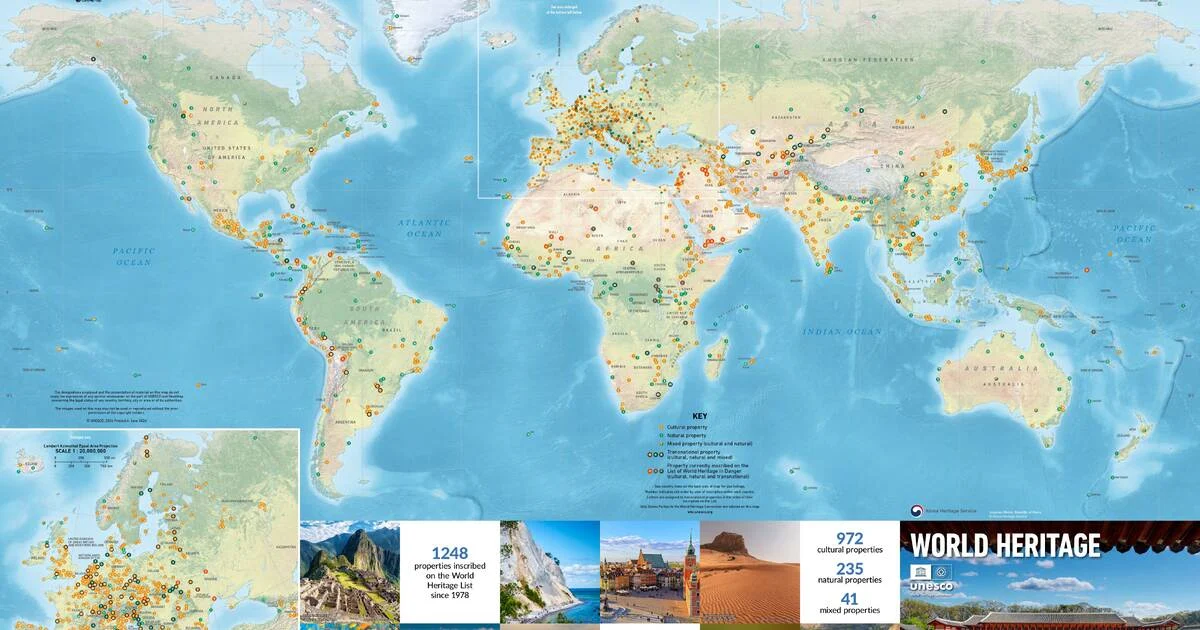
The preservation of global history is a monumental task, one that transcends borders, languages, and eras. In a digital age where information is ephemeral, the physical manifestation of our collective heritage holds a unique power. UNESCO has officially announced the release of its latest World Heritage Wall Map, a stunning cartographic achievement that serves as both an educational tool and a testament to the enduring significance of the world’s most precious cultural and natural sites.
Featuring all 1,248 designated World Heritage properties, the map is not merely a collection of coordinates; it is a visual pilgrimage through the annals of human ingenuity and the majesty of the natural world. Produced in collaboration with Geo4Map and supported by the Republic of Korea, this latest edition is now available for order, inviting enthusiasts, educators, and travelers alike to explore the tapestry of human civilization from the comfort of their own walls.
Main Facts: A Global Ledger of Significance
The 2024 edition of the World Heritage Map is a masterpiece of information design. Measuring at a large-scale, poster-sized format, the map acts as a comprehensive index of the sites currently inscribed on the UNESCO World Heritage List.
The map does more than denote locations; it serves as a gateway to the narratives of 1,248 distinct properties, ranging from the architectural marvels of Europe to the sprawling biodiversity hotspots of the Amazon and the ancient monoliths of Africa. Each site is accompanied by curated, high-resolution photography, offering a window into the aesthetic and historical depth of these locations. Beyond the imagery, the map provides essential data points, including the geographical distribution of properties across the various UNESCO member states and key statistical insights into the diversity of heritage types—be they cultural, natural, or mixed sites.
The Jongmyo Shrine: A Focus on Ancestral Continuity
The centerpiece of this year’s map is the Jongmyo Shrine, located in Seoul, Republic of Korea. Chosen for its profound historical significance, the shrine serves as the primary visual anchor for the 2024 edition.
Jongmyo is not just a relic of the past; it is a living monument. Dedicated to the kings and queens of the Joseon Dynasty, the site represents one of the oldest and most authentic Confucian royal shrines in existence. Its significance lies in the rare preservation of its original 14th-century layout and the unbroken continuity of the ritual practices performed there. While many historical sites across the globe have fallen into ruin or lost their cultural context, Jongmyo remains a site of active ancestor worship. Its inclusion on the map highlights UNESCO’s commitment to preserving not only physical structures but also the "intangible" heritage—the rituals, traditions, and belief systems—that define a culture’s identity.
Chronology: The Evolution of the World Heritage List
To understand the scale of the new wall map, one must understand the evolution of the World Heritage Convention itself. The project of mapping our global heritage began in earnest following the 1972 adoption of the Convention Concerning the Protection of the World Cultural and Natural Heritage.
- 1972: The World Heritage Convention is adopted, establishing the framework for identifying and protecting sites of "Outstanding Universal Value."
- 1978: The first 12 sites are inscribed, including the Galapagos Islands and the city of Quito.
- 1990s: The list expands significantly as the focus shifts toward a more balanced representation of global cultures, moving beyond Western-centric monuments.
- 2010s: The focus pivots toward climate change resilience and the protection of heritage in conflict zones.
- 2024: The current tally reaches 1,248 sites, necessitating a sophisticated and updated mapping solution to track the rapid expansion of protected zones.
The map acts as a historical record of this expansion, allowing viewers to see how the international community has collectively decided what is worth saving. From the industrial landscapes of the 19th century to the pristine coral reefs of the Pacific, the chronology of the list reflects the shifting priorities of humanity over the last five decades.
Supporting Data: The Cartography of Preservation
The production of this map is a technical feat managed by the UNESCO World Heritage Centre in partnership with Geo4Map. Mapping 1,248 sites requires more than aesthetic appeal; it requires geographical precision. The map incorporates:
- Spatial Distribution Analysis: By visualizing the density of World Heritage sites, the map reveals the "heritage gaps"—regions that are underrepresented on the list. This data is critical for the World Heritage Committee as they evaluate future nominations.
- Categorization Standards: The map distinguishes between cultural sites (e.g., historical cities, temples), natural sites (e.g., national parks, biological reserves), and mixed sites. This data helps the public understand that heritage is not just about human creation, but also about the preservation of Earth’s critical ecosystems.
- Digital Integration: While the physical map is a static display, its data corresponds to the digital archives hosted on the UNESCO website, allowing users to cross-reference the physical poster with deep-dive technical reports, conservation status updates, and interactive maps online.
Official Responses and Strategic Partnerships
The support provided by the Republic of Korea for this year’s map is a reflection of the nation’s long-standing dedication to cultural preservation. A spokesperson for the UNESCO World Heritage Centre stated, "The map serves as a vital bridge between our institutional mandate and the public consciousness. By bringing these sites into homes and classrooms, we foster a sense of shared global responsibility. The generous support from the Republic of Korea underscores the necessity of international cooperation in maintaining the integrity of our collective history."
Furthermore, the collaboration with Geo4Map was essential for ensuring that the cartographic standards meet the rigorous demands of UNESCO’s educational goals. The map is designed not just for display, but for utility, ensuring that the sheer volume of data remains accessible and engaging for non-specialists.
Implications: Why We Must Map Our Heritage
The release of this map is not merely an administrative exercise; it is an act of advocacy. In an era marked by geopolitical instability and the existential threat of climate change, World Heritage sites are increasingly vulnerable.
1. Awareness as a Shield
Public awareness is the first line of defense for a heritage site. When a site is recognized on a global map, it gains a level of visibility that can deter encroachment, urban development, or neglect. The map invites the viewer to acknowledge their role as a global citizen—someone who has a stake in the survival of sites that may be thousands of miles away.
2. The Educational Imperative
For educators, the map is an essential pedagogical tool. It provides a visual narrative for geography, history, and sociology curricula. By showing the interconnectedness of world sites, it helps dismantle nationalistic silos, encouraging students to see the world as a singular, fragile, and magnificent collective inheritance.
3. A Call to Responsible Travel
As global tourism recovers, the map serves as a guide for sustainable exploration. It encourages travelers to look beyond the "usual suspects" of mass tourism and explore the less-traveled, yet equally significant, sites highlighted on the map. It encourages a more thoughtful approach to tourism, one that respects the fragility of the cultural and natural environments represented.
Conclusion: A Living Legacy
The 2024 UNESCO World Heritage Wall Map is more than a piece of paper; it is a manifestation of the world’s "Outstanding Universal Value." By featuring the Jongmyo Shrine, UNESCO reminds us that heritage is a blend of the monumental and the ritualistic, the ancient and the practiced.
As we look upon the 1,248 pins on this map, we are reminded of the scale of the task ahead. Protecting these sites requires the continued vigilance of the international community. The map invites every individual to participate in this mission—by learning, by visiting responsibly, and by recognizing that the history of the world is, in the truest sense, our history.
For those interested in securing their own copy, the map is available through the official UNESCO World Heritage Centre website. It stands as a visual testament to what we have built, what we have preserved, and what we must protect for the generations to come. In every photograph and every marked coordinate, there is a story of human triumph, natural wonder, and the enduring quest to leave something of value behind for the future.
 Asep Darmawan
  Evan Lee Salim
  Jia Lissa